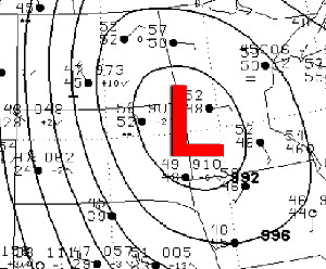
Isobar Maps are weather maps that use isobars to connect areas of the same air pressure. The maps are useful in locating high and low pressure gradients. The image above is a weather map showing the high and low air pressure in parts of the United State on On May 6, 1999. The map shows that there were some strong winds blown across western South Dakota and portions of northeast Wyoming. Each isobar represents a 4mb pressure difference. There were also 5 isobars over western South Dakota. The map also shows the direction of the wind.

No comments:
Post a Comment